Manchester area
New Islington
New Islington is known today as one of inner Manchester's flagship canalside regeneration neighbourhoods: contemporary apartment blocks grouped around a marina where the Rochdale and Ashton canals meet, anchored by the distinctive Chips building and Cotton Field Park.
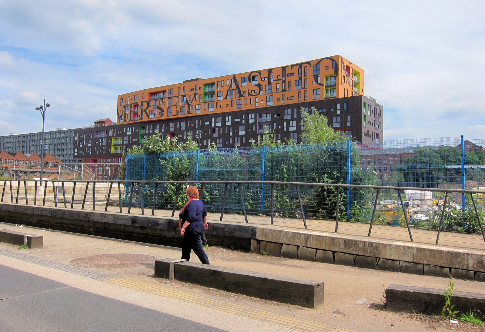
Image: The Chips apartment building in New Islington, Manchester, showing its three stacked, staggered blocks beside the canal by Alan Stanton (CC BY-SA 2.0)
New Islington, honestly
New Islington sits on the eastern edge of Manchester city centre, bounded by Great Ancoats Street and the Rochdale and Ashton canals, within the Manchester City Council ward of Ancoats and Beswick [1]. The name is old: "New Islington" is recorded from 1817 and appears on the 1840 Ordnance Survey map, describing a spot near where the two canals meet [1]. Through the Victorian era the area was one of Manchester's first industrial suburbs, dense with cotton mills and the terraced housing built for the people who worked in them [2].
Much of that housing was cleared in the 1960s as part of citywide slum clearance, and the low-density council estate that replaced it became known as the Cardroom Estate, after the cotton-spinning process rather than any card game [2]. The estate struggled for decades: local shops, pubs and the primary school all closed, and by the mid-1990s roughly half its houses stood empty or were occupied by squatters [3]. Regeneration began when developer Urban Splash took on the site in 2000. In 2002 New Islington was named one of seven government-backed Millennium Communities, bringing in funding from English Partnerships alongside Manchester City Council and the Manchester Methodist Housing Association [2].
The masterplan, credited to architect Will Alsop, was built around linking the Rochdale and Ashton canals with a new stretch of water rather than simply replacing housing block for block [2]. The first new homes, Islington Square, were completed in 2006: twenty-three houses designed by architects FAT for the Manchester Methodist Housing Association, built specifically to rehouse Cardroom Estate tenants, with FAT visiting each family during a five-month consultation before drawing up the designs [5]. Piercy Street followed with fourteen homes by dMFK, and a scheme called The Guts added eighteen more [2].
The building most associated with New Islington today is Chips, an apartment block on the water's edge designed by Will Alsop for Urban Splash and completed in 2009. Urban Splash described it as "three fat chips stacked on top of each other": three long, staggered blocks holding 142 one, two and three-bedroom flats above ground-floor commercial space, with canals on three sides [4]. At the centre of the neighbourhood is New Islington Marina, where the Rochdale and Ashton canals meet, next to Cotton Field Park, an eco-park with a boardwalk, an "urban beach" and floating wildlife islands built around a new canal arm [6].
Education arrived with New Islington Free School, opened to serve the growing number of families moving into the new housing; it joined the Co-op Academies Trust in July 2022 and now operates as Co-op Academy New Islington, based on Hugh Oldham Way by the marina [2][3][9]. The area continues to fill in: Urban Splash's Mansion House building, overlooking the marina and Cotton Field Park, has brought new waterside commercial units, with food writer Pippy Eats and natural wine specialist Flawd Wine among the tenants announced for the space [8]. Nearby, House of Esk, a wine and cocktail bar with a canalside terrace, opened at 6 New Union Street, Cottonfield Wharf [7].
A New Islington stop on the Manchester Metrolink's East Manchester Line opened in February 2013, connecting the neighbourhood directly to the city centre [1]. Two decades on from Urban Splash's arrival, New Islington is no longer the Cardroom Estate of the 1990s: it is a canalside neighbourhood built quite literally around its water.
Sources: 1. https://en.wikipedia.org/wiki/New_Islington 2. https://www.urbansplash.co.uk/blog/the-regeneration-of-new-islington 3. https://www.tutor2u.net/geography/reference/gcse-geography-urban-regeneration-in-manchester-new-islington-uk-city-study-manchester-9 4. https://en.wikipedia.org/wiki/Chips,_Manchester 5. https://www.architecture.com/awards-and-competitions-landing-page/competitions-landing-page/islington-square 6. https://www.visitmanchester.com/listing/cotton-field-park/18091101/ 7. https://ancoatsplus.com/2023/02/07/house-of-esks-new-bar/ 8. https://ilovemanchester.com/waterside-food-drink-new-islington-marina 9. https://www.get-information-schools.service.gov.uk/Establishments/Establishment/Details/139598
Written and last reviewed 10 Sep 2026 by Group CEO
Use New Islington, do not just read about it
Save the area, share a meeting point, or build a simple local loop from real places already on this page.
A simple way into New Islington
- 01Start hereCity Centre (nearby area)
- 02Keep movingNorthern Quarter (nearby area)
- 03Finish nearbyCastlefield (nearby area)
An orientation loop built from listings on this page, not live directions. Open each stop for current details.
Nothing here matches that. Clear the filters to see everything in New Islington, or search the whole city.
Local context
Background for getting your bearings in New Islington.
- New Islington Marina - twin-basin marina centred on Old Mill Street where the Rochdale and Ashton canals meet
- Chips - Will Alsop-designed apartment building for Urban Splash, completed 2009, 142 flats in three stacked staggered blocks
- Cotton Field Park - eco-park with boardwalk, "urban beach" and floating wildlife islands built around a new canal arm next to the marina
- Islington Square - 23 homes by architects FAT for Manchester Methodist Housing Association, completed 2006, first phase of the rebuild, rehoused former Cardroom Estate tenants
- Co-op Academy New Islington - primary school on Hugh Oldham Way, opened as New Islington Free School, joined Co-op Academies Trust in July 2022
- House of Esk - wine and cocktail bar with canalside terrace at 6 New Union Street, Cottonfield Wharf
- New Islington tram stop - Manchester Metrolink East Manchester Line stop, opened February 2013
- Mansion House - Urban Splash commercial building overlooking the marina, waterside units let to food and drink tenants including Pippy Eats and Flawd Wine
- Piercy Street - 14 homes designed by dMFK as part of the New Islington rebuild
- Old Mill Street - principal route through the development, built as shared pedestrian and vehicle space
More areas in Manchester
Ranked by how much is listed in each, not by distance.
Add to New Islington
This page is short of an event, a place and a story for New Islington. If you know one, add it and we will check it.
Keep New Islington right
Nothing here opens a new form. Every link goes to a page the site already runs.